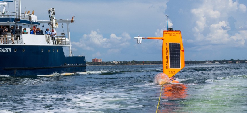
NOAA and Saildrone Launch Several Hurricane-Tracking Surface Drones

NOAA
The agency uses drones to collect hurricane data and help improve hurricane weather forecasts.
The National Oceanic and Atmospheric Administration, in partnership with ocean data solutions company Saildrone Inc., recently deployed seven hurricane-tracking ocean drones to help better understand the weather events and to improve hurricane forecasts, which will allow potentially impacted communities to be warned sooner.
The drones will collect data during the 2022 hurricane season. Two drones will track hurricanes in the Gulf of Mexico for the first two years. One was launched from St. Petersburg, Florida, and the other from Port Aransas, Texas. The other five drones will survey the Atlantic Ocean and Caribbean Sea and were launched from Jacksonville, Florida and the U.S. Virgin Islands.
“This season, NOAA will work with numerous partners to gather oceanic and atmospheric observations using a suite of platforms to monitor the conditions that play a role in hurricane intensity changes,” John Cortinas, director of NOAA’s Atlantic Oceanographic and Meteorological Laboratory, said. “Storms that intensify rapidly can cause extensive damage and loss of life, and real-time observing systems are crucial to better understanding the atmospheric and oceanic processes that lead to the formation and intensification of these hurricanes.”
According to NOAA, a challenge to hurricane forecasting “is predicting rapid intensification,” or when hurricane wind speeds increase by at least 35mph in a 24 hour period. In order to understand how a storm intensifies, scientists will collect data on the exchange of energy between the ocean and atmosphere by examining heat and momentum, which is reportedly best accomplished by non-crewed systems like drones.
Each saildrone has a special “hurricane wing” that looks like a hard sail and can withstand extreme wind conditions. The storm data is used to advance the understanding and prediction of changes to the intensity of tropical cyclones, while furthering knowledge of the ocean-atmospheric interactions that propel these changes.
In 2022, three of the saildrones will work in conjunction with one another using underwater gliders to gather “nearly collocated measurements of the upper ocean and air-sea interface.” The underwater gliders will have sensors to measure temperature and the amount of salt down to a half mile below the surface of the ocean. Additionally, the gliders will give high-volume, high-resolution data in frequent hurricane travel areas. This will hopefully help create more accurate intensity forecasts because of the improved representation of the ocean in weather models.
The sail drones will also coordinate with the Altius-600, a small uncrewed aircraft system, that will be sent into hurricanes for the first time from NOAA’s Hurricane Hunter aircraft to sample atmosphere a few hundred feet above the ocean’s surface. The goal is “to collect the first coordinated air-sea and atmospheric measurements in a hurricane from uncrewed ocean and aerial drones.” This will allow for the coordination of air-sea and atmospheric measurements in real-time to provide high-resolution data about hurricanes and improve future forecasting.
“Uncrewed marine and aircraft systems have the potential to transform how NOAA meets its mission to better understand the environment,” Capt. Philip Hall, director of NOAA’s Uncrewed Systems Operations Center said. “These exciting emerging technologies provide NOAA with another valuable tool that can collect data in places we can’t get to with other observing systems.”
NOAA noted that during last year’s hurricane season, a saildrone collected crucial data and the first video from inside a category-4 hurricane. According to NOAA, a recent study demonstrates that data taken from the saildrone wind measurements are consistent with those from satellites and moored buoys.
The saildrones will directly provide data to NOAA’s Atlantic Oceanographic and Meteorological Laboratory and Pacific Marine Environmental Laboratory. This data will then be processed in the Advanced Weather Interactive Processing System II—a visualization tool—to be used by NOAA’s Hurricane Center.


