New Computer Vision Model Tackles Improved Wildfire Prevention

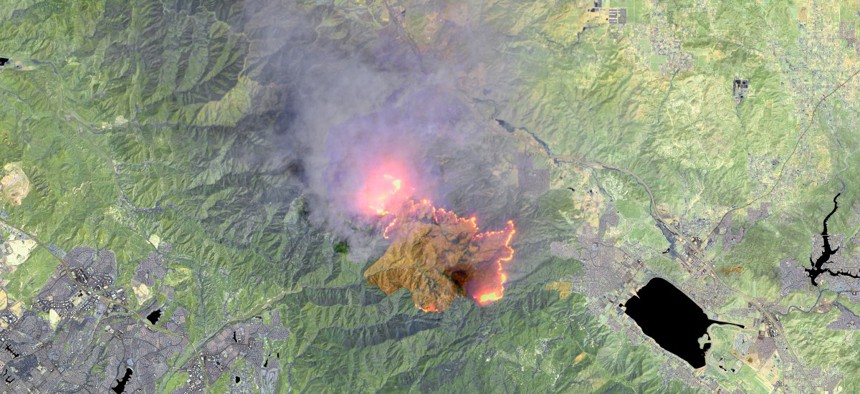
This is an enhanced Landsat-8 thermal satellite image of the Holy Fire, in Orange County, east of Long Beach, California. maps4media via Getty Images
The model uses satellite imagery to identify areas at risk of wildfires before they actually happen.
Hundreds of thousands of people in the U.S.—millions worldwide—have been affected by wildfires in 2022.
The U.N. Environment Programme reported in February that “climate change and land-use change are projected to make wildfires more frequent and intense.” The report projected a global increase of extreme fires of “up to 14% by 2030, 30% by the end of 2050 and 50% by the end of the century.”
U.S. efforts to manage wildfires focus 60% of funding on immediate firefighting responses. “Much less is spent on reducing fire risks in advance and helping communities recover in ways that could make them more resilient,” according to the New York Times.
To help address wildfire risks before they erupt, Accenture Federal Services has created a computer vision model that analyzes satellite imagery to identify dead and diseased trees in real time, providing land management groups better information on where to focus mitigation and resilience efforts.
“The effects of climate change are apparent,” said Maxwell Titsworth, analytics manager, AFS, describing the impacts from water levels in reservoirs to large-scale flooding. “The integration of these [images] is where large gains can be made by using satellite assets.”
Cody Champion, senior machine learning engineer for sustainability and geospatial analysis, was on the AFS team that developed the CV model for the Amazon Web Services Disaster Response Hackathon.
“We try to help analysts augment their analysis, and/or automate manual [tasks], like stacking images manually,” Champion said. “The technology that actually enables us to do this was only available in the past five or six years.”
The AFS hackathon team trained a CV model to identify, pixel by pixel, satellite images taken over a period of time, showing the spread of diseased and dead trees. The pixels then were classified, using a logistic regression with partial fit, to identify whether an area did or did not show tree mortality. The resulting model can be used on real-time satellite images to provide faster and more accurate information to the land management organizations, so they can plan more effective mitigation programs.
The model offers several possible benefits. First, it expands the area to be examined for tree mortality. Currently, the U.S. Forest Service conducts an Annual Insect and Disease Detection Survey of major forest areas within national forests, but it does not include many areas on the wildland-urban interface, where there are residents who could be at risk. This model can examine those areas and provide land managers with a better understanding of where those risks are growing.
Also, by better identifying the spread of invasive insects that kill trees, land managers at all levels of government can rapidly detect and monitor tree mortality over larger areas, enabling faster treatment of affected trees and better containment of the invaders.
Finally, by identifying dead trees near power lines, the model can reduce the risk of fires sparked by falling lines.
“On distribution systems, it is common for tree-related outages to comprise 20% to 50% of all unplanned power outages,” AFS said in its press release. “The vast majority of tree-related outages stem from tree failure.” Identifying dead trees can give utility foresters, regulators and others the tools to improve tree risk assessments and line clearance programs.
Titsworth noted the same CV model can be adapted to other hazards, and fusing different kinds of datasets—such as tree health and soil moisture—can provide a much more nuanced understanding of the interplay between different factors.
“I spend time with land management agencies; I really see an opportunity to augment the federal workforce,” he said. “They’re strapped in capacity. It’s really exciting to [provide tools] so they can do more with their limited resources.”


